
What a thrill it must have been, to explore these dragon mountains? To trod on land that no man had ever set foot on! To set eyes on landscapes that had never before been revealed! To summit a peak and gaze out over the edge; knowing that only then, had the path been set for future climbers. But, these rewards would not have come without strife and effort. Teams of men, lugging huge loads over treacherous terrain with the risk of fatal falls ever-present! Temperamental weather, that would in one moment drench all in sunlight and then soak with a thunderstorm the next! And the uncertainty of the road ahead! For every potential path to the top was a game of chance. A gamble on whether the road led to success or whether it was abruptly interrupted by the terrain! Yet these pioneers of the Drakensberg Mountains, whose legacies are honoured through the names of many landmarks, must have had a thrilling adventure.
These days, very little, if anything; of this majestic mountain range is left to be explored. Every peak has been conquered, every river traversed and every pass negotiated. The Bergs have been carefully mapped out. The safest and most accessible passes have been marked. The paths have been beaten flat by decades of explorers following in the footsteps of those that went before them. Bannerman, Leslie, Grey and many others alike are to thank for this. Yet, some parts of the Bergs, have for the most part, been left alone and to their own devices. There, the modern hiker can, even just for a brief period, be called an explorer. The choice of the way up, is up to the hiker. For a short while, you can feel as if you are paving the way for those to come. That was our journey up to Mafadi.
Mount Mafadi is the highest point in South Africa at 3450 meters above sea level. In terms of the grander scale of altitudes on this planet, it is insignificant; it being less than 40% the height of Everest. It is not a particularly difficult or dangerous peak to summit. It isn’t really all that spectacular either. In fact it is more like a little koppie on top of a large plateau. But; it is isolated and remote. Very few people make any attempt to summit it, thus the route to the top is ill-defined and the support infrastructure to get to the summit does not exist. As such, any climber attempting to climb Mafadi must be completely self-sufficient. There aren’t many guides going up that way and there are certainly no porters either. There is only one established camp in the area; and it is a far reach from the summit. There are no sign posts or water points; no c ell phone coverage or rescue services. Even the summit itself is non-distinct and difficult to locate. The weather changes by the hour. At lunchtime the entire range could be shrouded in mystery by the mist, but by dinner every cliff would display themselves in all their grandeur.
An expedition up to Mafadi must be carefully planned. Complete self-sustenance in a remote part of the Bergs is no trivial matter. This entails a variety of aspects: clothing and camp supplies; tents and sleeping gear; protection from the elements; food and cooking material and all the other accouterments needed for such a journey. All of which, must fit into a single bag, light enough to lug around for 5 days through the roughest of terrain.
But, all of that isn’t all that’s needed for such an expedition. Being well prepared is not just a matter of being well stocked. No, it is more than that! It is a matter of being well prepared in body and spirit. Knowing where you are heading and how to get there! Being physically fit and healthy! Being mentally tough and resilient! And in spite of all of this, you must expect the unknown. A moment where all the preparation in the world means nothing and only ingenuity counts.
And so, by the 30th of March, everything was ready and all that preceded the climb was a good night’s rest. We departed for the Injasuthi Hutted Camp, in the predawn hours of Saturday morning. The Drakensberg Mountains have a number of camp sites, littered along the entire length of the range. Some of these are rather easy to find, but others are inconspicuous and quite far off the beaten track. Injasuthi is one of these. It lies about 50km south of Winterton, in Kwazulu Natal, beyond the rural villages of Emoyeni and Engonyameni. Here, people still live lives of peace that are unaffected by the hustle of urban cities. Beyond these villages, tar roads are replaced by severely eroded gravel roads, which reduces driving speeds to that of a leisurely walk. We drove slowly and cautiously through these rutted roads. Thus, we arrived at the camp at midday and were only rigged and ready to go an hour and a half later. Our first of many delays! Almost as if it were an omen of what was to follow! It had been raining quite heavily on the days leading up to the climb and it continued to do so for most of the drive down to Injasuthi. A second omen! The significance of this would later be revealed.
Day 1: Navigating the Injasuthi
Starting point and elevation: Injasuthi Hutted Camp at 1470m above sea level
End point and elevation: Lower Injasuthi Cave at 1800m above sea level
Distance travelled: Approximately 7.5km (SSW)
Our team consisted of 7 individuals, 4 teenagers and 3 adults. All of us being fairly experienced hikers! I had, 18 months earlier, conquered Kilimanjaro, the roof of the continent. I was brimming with self-assurance; bordering on arrogance! We departed from the camp site, just as the rain began to fall again. The Injasuthi camp is named after the river that flows, not just through the camp, but all the way along the main hiking path as well. We trekked along this path, which skirted this river, for about 2km  before the path turned abruptly directly into the river. As with most Berg rivers, the Injasuthi flows strongly at the lower reaches of the range. Looking out across the river, which at that point had gathered the momentum of a 1500m descent, I feared the worst. The rain had swelled the river to beyond its normal banks. On the other side of this watery chasm, we could see the path emerge again. However, we still searched for an alternative crossing. We searched in vain. This point where the river cut the path was to be our way through.
While the river was easily traversable on foot, we each still needed to get 20kg of gear across, and we needed to keep dry for the journey that was still to come. A chain, which had previously been installed as a guide rope to cross the river, laid neatly inside the river with the opposite end broken at the joint. The rocks that could normally be used to skip across such a river were all beneath the level of the water. Thus, this crossing needed to be done without the assistance of the guide chain, directly through the river. Only one option existed: wade barefooted all the way across, while balancing our gear on our backs. The river wasn’t too deep and so we found a route that appeared to be just above knee height in depth, but with a strong current that would tug away at each footing. We stripped off our shoes, secured them to our luggage and slowly started walking across.
Balancing with a bag that was close to a third of my body weight, while barefoot, inside a river with an uneven floor, whilst trying to cautiously manoeuvre forward, was a new challenge altogether. One for which I was totally unprepared. I started the crossing nervously; and I slowly edged forward. But the river started getting deeper towards the far end. At one point a number of boulders inside the river created a narrow channel that caused the river’s flow to increase. I was caught by surprise; and as I stepped into the channel, I lost my balance. I knew that I was going to fall over. In that moment I knew that should I fall over, I was going to end up farther down the Injasuthi, wherever it decided to spit me out. This was not an option. So, out of desperation, I decided to lean forward, and immerse my hands into the water to regain my balance. My hands searched deep for some sort of purchase until it eventually found the bottom of the riverbed. This resulted in me being emerged in the river up to my chest. I then waded the rest of the way on all-fours. I must have looked like a pet dog paddling in the water. Fortunately, I managed to keep my head and bag out of the river. Okay, so a pet dog wearing a backpack, paddling through the water! I emerged on the other side, soaked from the waist down. My pride in my pocket, I trudged to a dry rock to redress my feet. This, I realised, was going to be the trend of the trek. Long walks followed by tedious river crossings.
I related this story, not because of its significance, but rather to demonstrate what the rest of the trip entailed. On a normal year in late March, the Injasuthi would have flowed weakly. But this year it was a torrent; thanks to the recent rains. We hiked along the Injasuthi for all of the first day and a large part of the second day too. And during this time, we crossed the Injasuthi several times. And each time, it was the same arduous process of crossing. The taller, stronger guys managed to leap across the river by rock hopping. I neither trusted the distance I could jump nor the balance I could maintain. So, I took the safe route… directly through the river, using my hands for balance. Needless to say, this was a frustratingly time consuming process. My self-confidence was quickly cut down to size. Kilimanjaro, with all its highway-like paths never presented a challenge like this.
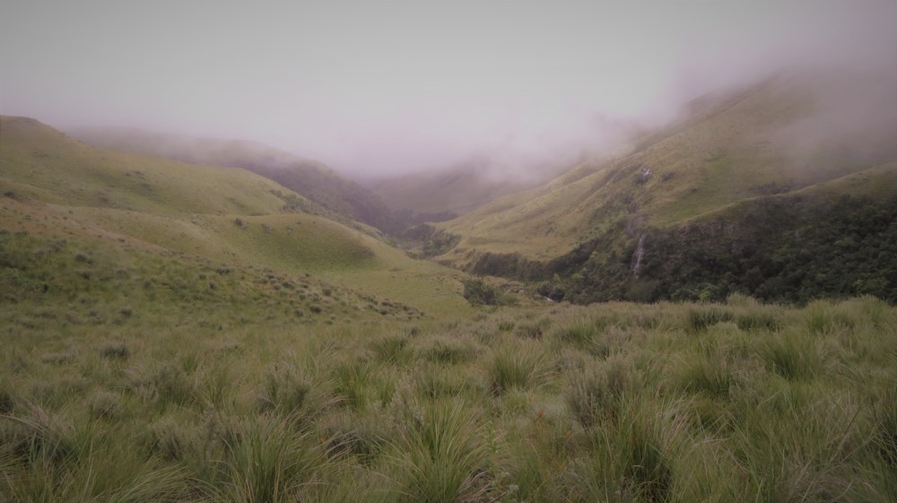
Right, so back to the journey! After that first river crossing, we continued along the Injasuthi. The rain fell intermittently, but regularly. The path was wet and overgrown. The wet vegetation along the path was more successful at drenching us than the rain or the river. It seemed that each blade of grass permeated my boots with every step and then deposited a drop of water inside. It started with my socks becoming damp, then wet and eventually drenched. So much so, that during every rest break I would pour out a mouthful of water from each boot. Nothing is worse than wet feet, when you still have more than 50km of walking ahead. The cold feeling of wet socks! Of water squishing between your toes with each step! It was truly depressing. Nonetheless, the walk was lovely. The mountains hid themselves in a veil of mist for the entire day but the beauty of nature abounded.  The plant life in the Bergs is always a pleasant site. Flowers were still in bloom, the vegetation still lush and the trees still green. And it is in quiet times like these, when the mind must focus, that nature’s splendour can truly be appreciated.
We arrived at our first camp, the lower Injasuthi cave, at around 18:00. As it turned out, this was the only day where we actually made it to the planned camp site. From there on, each day ended where the mountain dictated it should. The lower Injasuthi cave is more of an overhang inside the rock, than an actual cave. Still, it provided sufficient shelter, was level and spacious, but rather far from a good water supply. Quite ironic!
Day 2: Die Soekpad
Starting point and elevation: Lower Injasuthi Cave at 1800m above sea level
End point and elevation: Centenary Hut at 2210m above sea level
Distance travelled: Although it should have been just 7.5km, it was closer to 11.5km (SE)
We awoke the next morning to a dense mist, which, we knew, would make navigation challenging. We packed up and departed from the camp at around 08:00. For some reason my bag felt heavier on this day. This was counter-intuitive as one would have expected the bag to get lighter as supplies were used up. Whether this increase in mass was due to my wet clothing or just a figment of my imagination, I do not know. What was certain though, was that it was a huge load on my back. A load that would test me to the edges of my physical strength as the days wore on! The mist hung heavy as we departed camp, but fortunately we still had a path to follow… for a few moments at least. We trekked for a short distance till we reached a fork, where we took the path that led deeper up into the mountains. This beaten dirt path could not have lasted for more than a few hundred meters, before it suddenly disappeared. So there we were; in the middle of the mountains with no clear path to follow and no visible features to navigate from.
Now, the Drakensberg maps are fairly accurate and provide sufficient detail for any hiker to steer, but it still relies on the reader knowing his location. The paths are labelled from clearly defined highways down to soekpads; a path that exists in theory but isn’t actually there. To make the situation worse, our GPS malfunctioned. We knew that we needed to cross a stretch of land and eventually intersect the Contour path. The Contour is a pathway that traverses along, almost the entire length of the Drakensberg range at around 2200m in elevation. It is one of the mountain’s highways and is used as an access point up to most of the mountain passes. According to our map, this Contour path was not more than 2km away… if only we knew where we were.
With no clear indication of our exact position, no GPS, no visible peaks to help us orientate ourselves and no path which to follow; our ingenuity would be tested. Our lead guide was quite an adept navigator, but even he was challenged by the situation. We walked in the direction that seemed most likely to be correct. Then we turned back  and circled back around. Then we zigzagged across a ledge. Then we doubled back, headed up, then down, until finally, at around midday, we intersected the Contour path. All the while, we walked through long, dense grass that continued to transfer water into the soles of our boots. I then fully understood the concept of a seek path. It is quite literally a path for which you must constantly seek. On that day we were truly adventurers in a lost land.
Desperately behind schedule, we headed along the Contour path. The going was a lot easier and we were able to maintain a better pace, but making our next planned camp was becoming less likely as the day wore on. We were heading for Bannerman Hut at the bottom of Bannerman Pass. However, at around 16:00 while walking past Centenary Hut, the temptation for rest and a dry camp was just too much and we decided to make the first amendment to our plan. I welcomed the change with open arms. My boots and the lower parts of my hiking pants were drenched. My bag clawed at my shoulders as I struggled against its ever-increasing weight. I longed for a dry place to air my wrinkled feet and rest my worn shoulders, and the Centenary Hut called out lovingly.
The Centenary Hut is pretty run down. Years of abuse by irresponsible hikers as well as pillaging has left the hut in a dilapidated state. In my state though, I would have taken a tin shack. Nonetheless, it provided shelter, warmth and a spot to dry out our gear. The sun eventually mustered up the power to burn off the mist just before sunset. And finally, the big peaks were revealed in all their majesty. The Judge, Popple Peak, the Trojan Wall and even Monks Cowl and Champagne Castle came into sight. For those brief moments, before darkness again robbed us of our view, we appreciated why we were really doing this. Views such as these cannot be appreciated in a picture or even in a description. It must be seen to be truly esteemed. Those views and the brief chat with my wife, did wonders to lift my spirits. Because; while this was not my first such endeavour, it was certainly my toughest. And when the body is pushed beyond its normal boundaries, it is the mind and soul that carries you on.
Day 3: The Judge
Starting point and elevation: Centenary Hut at 2210m above sea level
End point and elevation: Just South of the Trojan Wall at 3100m above sea level
Distance travelled: 15km ![]()
 Now one change in plan normally dictates another. So on the morning of day 3, we devised a revised plan of action. This was to leave Bannerman Pass, and go up Judge’s Pass instead. We had initially chosen Bannerman Pass based on the good ratings we read online. But, because we had not made our initial planned camp on day 2, we had to tackle the closer, but lesser rated, Judges Pass. But, in the situation we were in, it was our only option if we were to summit and arrive back at the Injasuthi Hutted camp on day 5. New plan drafted, we headed back out on the Contour path in a southerly direction.
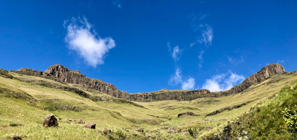
The morning of day 3 was lovely. The sky was clear and the sun shone brightly, setting the scene for the best day of hiking. Better still, the sun’s rays offered us an opportunity to dry out our wet gear. While this may seem trivial; I will struggle to explain the joy of being able to walk with dry feet inside dry boots after trekking in water logged boots for 2 days. But, the best part of the day, was what nature itself dished out. One magnificent view after the next! A visual fantasy, not too different to the journey of Frodo and Sam travelling through Middle Earth. All day long, we looked out at majestic vistas in every direction, whether it was down over a gaping valley or up at a scaling peak. It boggles the mind to stare up at a cliff. All senses of distance and height become muddled. The closer you get to a cliff the more intimidating and imposing it becomes, until it dominates your very being. As it completely blots out one end of the sky, even the sun seems frightened. I started to question my physical ability, and the challenge of the upcoming climb through the pass started to work on my mind.
We trekked along the Contour path and intersected the Corner Pass, where for a brief time we lost our way on one of those seek paths again. Yet another delay! We arrived just after lunch at the bottom of Judges Pass, named after the peak that guards its higher reaches. This pass led up from the intermediate level of the mountain to the higher plateaus.
The Drakensberg Mountains are different from other ranges in that it does not rise and fall as one would expect. When viewed from above, it does not look like a spinal cord that goes up on one side and down on the other. Rather, it climbs rapidly from east to west, until the top, and then very gradually descends in a westerly direction. In fact if you consider that the Drakensberg Mountains are part of the larger Great Escarpment range, then the top of this range descends for more than 1000km. It is best described as an upside down plate, where the rim represents the low-lying coastal regions of South Africa and the middle, raised portion, represents the country’s higher interior, with the Escarpment being the bits in-between. So, when one gets to the top of any part of the Bergs, that top is really a massive plateau atop of which lies the majority of the Southern African subcontinent.
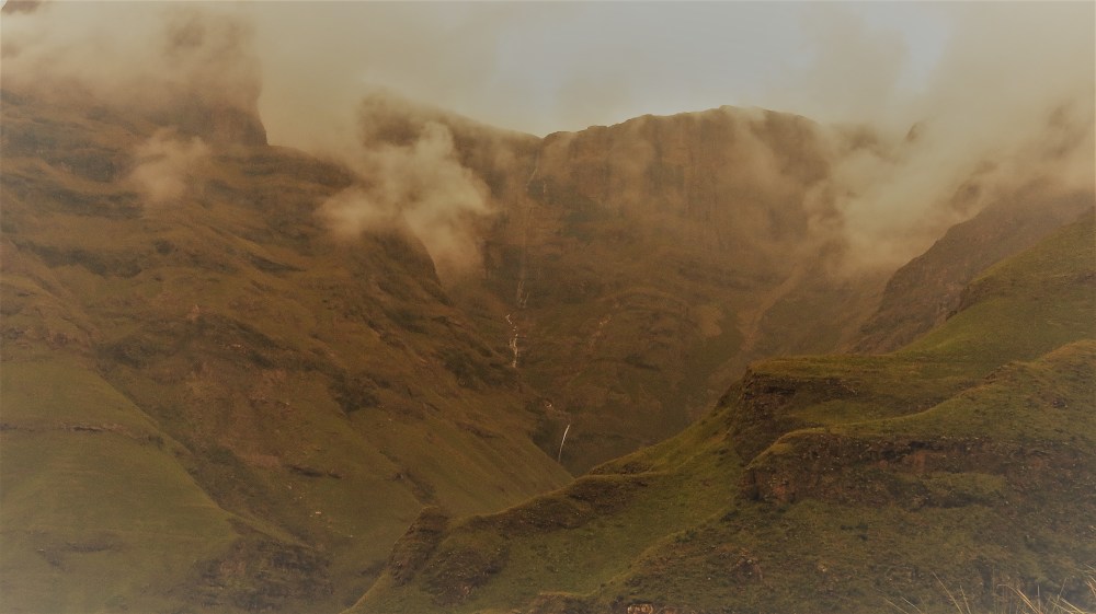
The first rise of the Great Escarpment starts at the east coast and then gently ascends towards the west until the Drakensberg base at 1400m above sea level. From here, the Bergs take over and the rise becomes more rapid and intense. Initially, the rise is characterized by hills rather than cliffs and continues as such until it reaches a smaller intermediate plateau, at around 2200m above sea level. The Contour path attempts to circumnavigate this intermediate plateau that continues adjacent to the Bergs for almost its entire length. Then, there is the final ascent of the Dragon Mountains. This final ascent, leading to the top plateau is guarded, for the most part, by impenetrable vertical cliffs. In some places, these basalt cliffs can be higher than 1000m from base to peak. The only gateways into these walls of rock are through the passes that cut into the cliffs.
 These passes have the appearance of deep gashes in the rock, almost as if some gigantic beast struck down onto the cliff faces with a huge axe. The passes are wider at the bases, but narrow towards the higher reaches as the cliff faces pinch closed. Sometimes they would pinch closed completely, cutting the pass off before the top. Some passes can be negotiated with ease while others are tougher and more technical to navigate.
And then there is the top and final plateau! Soaring at heights of more than 3000m in some areas! The highest points of the Bergs reign up here. The plateau is filled with hills and valleys that are less spectacular and rugged compared to the cliffs and passes that edge them on the east. As one traverses this plain, various hills will reveal themselves. Mafadi is on the summit of one of these hills. It is a non-distinct little koppie, that sticks out above the surrounding land, just enough to make it the highest point in South Africa.
 We climbed up, from the point where the contour path intersected Judges Pass at 2200m above sea level. The pass was less than 2km long, with a gain of more than 900m and an incline of around 1 in 2. This was backbreaking stuff. It would be a true test of character and body. The Judge’s verdict awaited. We struck out, on and skyward! But my fears were never realised. For while every step was an exertion, it was ever closer to our destination. My mind never gave in and my muscles never failed. Judges Pass may not have been recommended, but as we worked our way to the top, it became obvious that it was doable. At certain places we needed to scramble over rocks, but for the most part, Judges was fairly calm.
The views of the Judge and Popple Peak as we walked up were impressive. At times, we could make out the shape of a Judge in the rock, leaning over his table about to pass out a sentence. But this could have just been imaginative creativity. Looking down, back at the way we came, was just as splendid. The valleys, which were still bathed in sunshine, were a sight to behold. Finally, towards the top of the pass, the walls of the cliffs closed in and the path became less defined. But, there was only one way to go… up and through the gate. We found a cairn at the top, marking the end of the pass and the edge of the plateau at 3100m above sea level. The verdict… not guilty!
While Kilimanjaro soars at close to 6000m above the sea and its peak is filled with ice, it is a walk through the garden compared to this. The summit is reached with just a simple day pack, as you return the way you ascended. Guides and porter are always at hand. The hiking paths are like roads where rows of people can walk abreast. The weather is variable, but keeping dry is easy. There are no water crossings, no boulder hopping, no seek paths. If your lungs can survive the thin air and your body the cold, Kilimanjaro is conquerable. The remoteness of Mafadi, while still rich in oxygen, is littered with trying obstacles. Mafadi is not so easily defeated.
We were tired, and our next camp, the upper Injasuthi cave, was not too far away. But yet again, we found ourselves falling further and further behind schedule and for a second time we made a call to make camp in an unplanned location. This time, we camped alongside a pleasant little river in a clearing somewhere in the Lesotho Highlands. The unsettled weather had started to move back in as we exited Judges Pass and by the time we finished our dinner, the heavens opened up and dished up an awesome thunderstorm. The storm wasn’t particularly violent, but bolts of lightning struck close by all around us, almost as if to warn us not to go any farther. It was on this night, that I was thankful for my 3-season tent, for while the storm raged outside, I slept peacefully inside.
Day 4: A Summit with an Indecent Summit Descent
Starting point and elevation: Just South of the Trojan Wall at 3100m above sea level
End point and elevation: Somewhere close to the Buttress Fork at around 2100m above sea level, but peaking at 3450m above sea level on Mount Mafadi
Distance travelled: 19km (N)
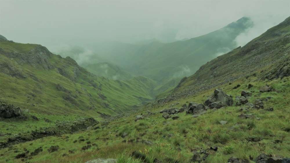
 The storm had abated sometime during the night and we awoke to a misty, but dry morning. It was however unbelievably cold. I had been told that temperatures drop by 3 degrees Celsius for every 1000m gained in altitude. This, I could now truly believe. After a short breakfast, we were on our way towards Mount Mafadi, the climax of our expedition. Within a very short distance, we climbed to an elevation of more than 3300m above sea level as we crossed over the Injasuthi Dome. Again, this part of the trail was unmarked, except for the game tracks that were created by the Lesotho Highland farm animals. While these tracks helped to maintain a general sense of direction, they did very little to orientate. And, with the mist having rolled in, navigation was again a serious challenge. We made use of our compass as well as a reliable altimeter, while keeping sight of the eastern cliff edge and we made our way cautiously to our destination.
We knew we were close. We had already climbed to 3400m above sea level. But the actual point of Mafadi still lay hidden behind the mist. We were beginning to wonder how we would ever know which hill to summit. And to make it worse, we were pressed for time! Then suddenly, for all but a brief moment, the mist cleared. This allowed us one quick survey of the land and a sight of, what was most likely, Mafadi. It was nothing special! One would imagine that the country’s highest point would strike a sense of awe to any onlooker. That from its surface, the world would reveal itself! It was nothing of the sort. In fact, a passer-by, would probably walk right by this peak without a second thought.
The top of Mafadi is a flat pickle shaped surface with a rocky floor, about the size of an average suburban home. The cairns hinted that we were probably on the correct summit. Something that we only really verified when we were back in the comfort of our homes. Still, although unspectacular, to summit a great peak is an indescribable feeling of accomplishment. To know you have pushed your body and mind to its limits and reached a place where a few have set foot, is deeply satisfying.
After a few photo shoots and a second breakfast we started our journey back home. Navigating was still tough and it took us a little longer to find the entrance to Leslie’s Pass, our way off of this Plateau. However, all through the day we were confronted with the beauty of this landscape. Wild horses interspersed randomly along the plains! Local herdsmen with their packs of dogs guarding their precious possessions! And every now and then, the mist would clear momentarily to reveal a distant peak or a spectacular rock formation. I particularly enjoyed that part of the walk, up on the summit of Southern Africa, skirted by ragged cliffs on the east and rolling valleys on the west. That was until we reached the mouth of Leslie’s!
 Leslie’s was meant to be one of the better Drakensberg passes. It should have been well trodden and the descent fairly gradual. It was anything but that. It was a skirmish, a tortuous and at times, a dangerous descent. Much of the path had been washed away and at two places it was actually blocked by a land slide. The road was slippery at times, extremely steep at others and at some places, both slippery and steep. Still, the views that encompassed us were truly beautiful. This included a gorgeous cascading waterfall and a rock formation, called the Molar. An isolated protrusion of rock that looked like the lone tooth in an old man’s mouth.
My body was utterly aching by the time we got to the bottom of the pass, but we still had a way to go to get to our planned camp at the Marble Baths cave. We had around an hour of daylight in which to find the caves. The boys set a blistering pace and I tried to follow, but I barely kept up. The feeling of accomplishment, only a few hours old, was now a distant memory. Not wanting to hold anyone up, I still pushed. Every muscle in my body ached. My shoulders were rubbed raw by the straps of my backpack. My hands were calloused and my feet were burning. My legs felt like jelly. My balancing muscles no longer worked automatically but required a mental effort to keep them upright. The pain in my body could only be eclipsed by the numbness of my mind. I began trudging in a stupor. Each step, masked in fatigue, was a simple mechanical action that was only powered by my will. The hills and valleys faded from my mind until everything around me became a blur of green. And then it happened!
I had been walking on a narrow path along the side of a steep hill. One of my feet stepped on top of a long clump of grass, trapping my other foot underneath and I tripped. Almost as if I had tramped on my own open shoelaces! I fell sideways off the path. I rapidly slid down the side of the hill, which sloped for a few meters down before reaching a cliff that plummeted down to a river. My mind quickly regained its lucidity. I realised that should I slide much further, momentum would grab me and haul me over the edge. By some miracle, I managed to grab onto a few clumps of grass. Not the strongest anchor against a fall! I held on with a vice-like grip and I hoped, against all practicality, that the roots held. They stayed strong! Those two insubstantial clumps of grass, which could have been there that day and gone the next, was all that saved me from a potentially fatal fall. That, and the grace of God!
I knew then, that God was with me through every minute. All the prayers, my own and those of my loved ones, were heard. But it wasn’t just in that moment where He held me. It was when my foot slipped in the river on day 1, when I was trudging in wet boots and when we were lost on the seek path. He was even there when we found Centenary Hut and the sun came out to dry our clothes. He revealed the majesty of His creation, not just for our pleasure but for our inspiration too. But why like this and on a trip meant to be recreational? Because in times of physical weakness, where external disturbances are removed, our minds are more prepared to witness God work. And so God worked; giving me enough food for the challenges of life that laid ahead.
In awe and thankfulness, and feeling a little jittery, I walked on. This time focusing intensely on every step. God saved me but I would not take advantage. By 18:00 we had only made it pass the first major river crossing in the valley, so for the third day in a row we decided to camp in an unscheduled location. To attempt to navigate, in the darkness, through what was now dense thicket, would have been madness. So we camped adjacent to a river on a thick bed of grass. This was a cramped camp space and probably the least practical of all our sites. But for me, it was by far the most comfortable. It was warm and the floor was soft and through my exhaustion, I slept in serene peace.
Day 5: The looong walk home
Starting point and elevation: Somewhere close to the Buttress Fork at around 2100m above sea level
End point and elevation: Injasuthi Hutted Camp at 1470m above sea level
Distance travelled: 14.8km (NWW)
 By our interpretations, we had just 8.5km to go before we reached the Injasuthi Hutted camp where we had left our vehicles. Depending on our pace, we could have easily arrived there before lunch. But, the Bergs had other ideas. The path was overgrown and navigating through, was difficult. We had multiple river crossings, even more than we had on the first day. And each time, I went through the same arduous process of removing my shoes, crossing safely and then putting them back on again. Then, we had a longer than scheduled stop at the Marble Baths. This though was well worth it. The baths, formed by the eroding powers of the river, had the look of an ancient Roman pool. Finally, there was the distance. We ended up walking 15km instead of our planned 8.5km. This day, had fewer climbs and descents and the going was much easier. So while this was a long day, it was little calmer on the body. There is something about knowing you are on your way back home to your loved ones.
This Mafadi hike turned out to make everything that I had done before seem trivial in comparison. In the end, unlike Kilimanjaro, I will remember the journey and not just the summit. In fact, this was not about the summit at all. It was about each little adventure along the way. Every obstacle was a triumph in itself. The mighty Kilimanjaro is a stroll compared to Mafadi. But the sense of triumph is unmatched. It is not only the fact that it is bodily and mentally demanding, but it is the fact that for 5 days we were completely self-sufficient. Everything we needed, we carried on our backs. We were close to God and one with nature. For a brief time we were explorers. Pioneers of this beautiful land! In charge of our own destiny! There is no better time or place for self-reflection and meditation than on a journey like this. And while we ended up with drained bodies, our spirits were renewed.


What a read! I felt like I was on this grueling but rewarding journey with you. And your attention to detail is really impressive. Well done!
“There is probably no pleasure equal to the pleasure of climbing a dangerous Alp; but it is a pleasure which is confined strictly to people who can find pleasure in it. “ -Mark Twain
LikeLike
sounds amazing!
LikeLike
Thanks for reading it Lucelle. This blog of mine has been starved of traffic of late
LikeLike