
One of the most breathtaking geological features in South Africa is the Great Escarpment. Southern Africa is shaped like an inverted plate with only the coastal areas being at sea level. Journey inland from any coastline and you will almost immediately rise in altitude, often by more than a 1000m in a relatively short distance. These rising slopes surrounding the coastal rim of the sub-continent make up the Great Escarpment. The normally flat highlands of the interior often mask the splendor of this escarpment. In some areas the interior was pushed up so violently that the earth was fractured at the joints, leaving sections of the escarpment magnificently altered. Nowhere can this be better experienced than along the Mpumalanga Panorama route. The route rages through a spectacular section of the Great Escarpement often delivering, as the name suggests, a panoramic view of the surrounding country. My 140km Panorama route begins in Lydenburg and ends at the Blyde River Canyon, through the R37 and R532. We start by heading east towards Sabie along the R37.
The R37 offers travellers the most dramatic rise and fall that can be experienced on a South African road. Leaving Lydenburg at 1373m above sea level, you will climb to 2150m above sea level within 20km, the highest point on any main road in South Africa. The temperatures up there dip significantly as the crosswinds negate the sun’s rays. The landscape is is littered with rocky outcrops among rolling fields of long green grass creating the calm before hitting the first major descent down the Great Escarpment. The next 36km drops more than a 1000m, landing in the picturesque town of Sabie at 1062m above sea level. The road is in excellent condition and filled with hairpin bends skirted by skyscraping cliffs and gaping valleys. This is not an invite for people, especially the guys, to test out their rallying skills.
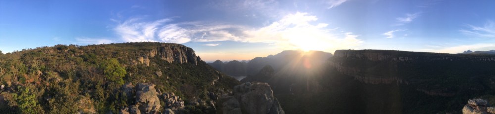
A traveller’s route is more than the just a pretty drive, it’s about the stop overs along that route. It’s about the things that extend the trip from 2 hours to 2 days. Here the short photo stops include a number of magnificent viewpoints (see featured image) where, on a clear day, you can ogle down the escarpment vistas. There is a simple sign at the pinnacle of the pass indicating the elevation. Great for a selfie! Not long after this sign is the so-called highest brewery in Africa, Hops Hollow. This rather dubious claim is challenged by a brewery somewhere in the Ethiopian Highlands. Nonetheless, Hops Hollow can be considered for accommodation or for just a pint of the local brew. Long Tom monument can be found about 20km before Sabie. It commemorates the Long Tom canons that were used to defend the route between the then Transvaal capital, Lydenburg, and Lourenço Marques (now Maputo) during the Anglo-Boer war. The road is aptly named the Longtom pass. Accommodation along the route is aplenty especially in and around Sabie. The cool climate in the area between Lydenburg and the higher portions of the pass allow for decent fly fishing. With the splendor of the pass, it goes without saying that there are numerous hiking trails, from the clearly marked tracks around Sabie to the less beaten tracks at the peak of the Great Escarpment. There are 4 nature reserves along this short stretch including Gustav Klingenbiel, Sterkspruit, Mount Anderson and Makobulaan.
Sabie is one of many famous little holiday towns in Mpumalanga. It is a perfect base camp to explore the great escarpment thoroughly. As with many of these Eastern Mpumalanga towns you have to escape the curio sales, which to me are just all much of a muchness. However, if you seek natural beauty then Sabie is on the doorstep to magnificence. The Wild Fig Tree is delightful restaurant with exquisite cuisine and the Woodsmen is a popular pub and grill with a cool vibe. Either of these two spots is perfect for a quick stop on this alternative “garden route”. So now, even more so after the pint of beer, restrain the rally driver in you.
From Sabie we head north on the R532 towards Graskop. The drive through this section is less spectacular than the Longtom pass. Most of the route is surrounded by man-made pine forests. However the true allure lies just off the main road. The area is littered with waterfalls as rivers flow East, plummeting down the escarpment, towards the Indian Ocean. The most notable of these falls are; Sabie, Bridal Veil, Berlyn, Mac Mac and Lisbon. Some, like Mac Mac Falls, are accessible by car but for some of the others, like the Bridal Veil Falls, you actually need to work to see them. There is something peacefully captivating about the flow of water. Whether it is a roaring torrent like Augrabies, a gentle meander like the Vaal or just a little drop over a small ledge! Therefore don’t discount some of the smaller falls in the area, they are beautiful and romantically remote. Make of that last statement what you will! In some places the original Forests were left untouched and the falls in that backdrop is stunning.

Graskop is another small trinket town and seems to be covered in a perennial blanket of mist. It is the location of the original Harrie’s Pancakes, which opened in 1986. If you do one thing in Graskop… Eat a pancake at Harrie’s!
Now it’s here at Graskop that a debate can ensue as to which garden the route should follow. You can head east towards Pilgrims Rest (yet another trinket town) or you can head North towards the Canyon. For the smart traveler the route North should be an obvious one. However, if you do decide to head East, against my better judgement, you will encounter one of the most twisty, hairpin-filled roads in the country. Pilgrims Rest is an enjoyable town but has declined a bit since the 99 year leases expired a few years ago. Nonetheless, you can still get a feel of the 19th century gold rush for which the town is known.
The wise traveler heading North, will continue to find stunning scenery and hiking trails. The best view of the escarpment is from God’s Window. It’s an easy hike from the stopover point along the main road and the ethereal view will take your breath away. It’s as if you are looking down from the ledges of Heaven, thus the appropriate name: God’s Window. The fractured earth in this area has produced some of the most stunning geological features in the escrapment. Because to the North is Bourke’s Luck Potholes, the Three Rondawels and the Blyde River Canyon.

The potholes vary throughout the year, but more in terms of what you see, rather than the beauty of the place. Huh? Okay, let me explain. During the rainy seasons, the high volume of water gushing through the gorge is spectacular in itself but it blocks out the rock formations. During the drier seasons, the water features are less spectacular but the actual potholes are miraculously revealed. Therefore, Bourkes Luck Potholes is worth a visit at any time of year; blazing sun or snow. If you actually experience the latter in this part of the world, you will receive a pot of gold from the winter monsters.
The Canyon and the Three Rondawels reside together with the rondawels actually within the Canyon. This writeup will truly struggle to describe the magnificence of the canyon. The precipitous views from any of the rims are awe-inspiring. The view of the sunrise, as seen from the western ledge, is spine-tingling. During the course of the sun’s ascent, the canyon’s colors changs and swirl as if it is a living being. The gorge changes from a menacing black pit to a pastel painting and finally to a glowing diamond.
The claimed relative size of the canyon must be discussed. Now we love to rate things according to size, especially us men. Not sure why! It is commonly stated that the Blyde River Canyon is the third largest Canyon in the world, behind the Grand Canyon in Arizona and the Fish River Canyon in neighbouring Namibia. However, all three of these claims are questionable at best. In fact every country with some sort of gorge or canyon claims that theirs is larger. Picture a group of boys on a playground! So here are the facts about the canyon: It is 27kms long and has an average depth of 750m. The predominantly sandstone structures were cut by the Blyde (Happy) river. The highest point is about 1900m above sea level and lowest point is 561m. Now you decide.
The green nature of this canyon makes for a more interesting visit than simply looking down a massive hole. The fauna and flora are aplenty including all five of South Africa’s primate species. There is a resort located within the Canyon reserve, a great base to explore the rest of the Canyon, from dangerous hikes to a boat cruise on the Blyde River Dam. Here you will find a unique and special place in our diverse country, where nature is displayed like a museum masterpiece, to be marveled at. A perfect destination to end this “other” garden route.
